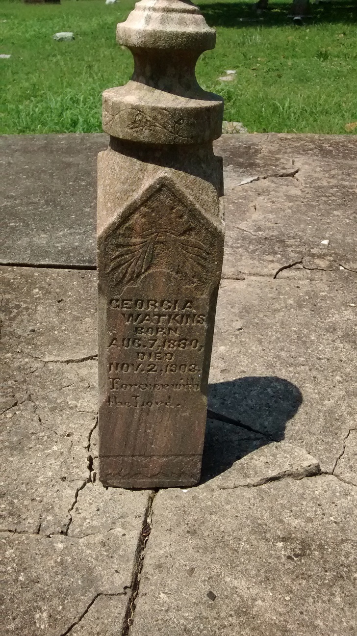
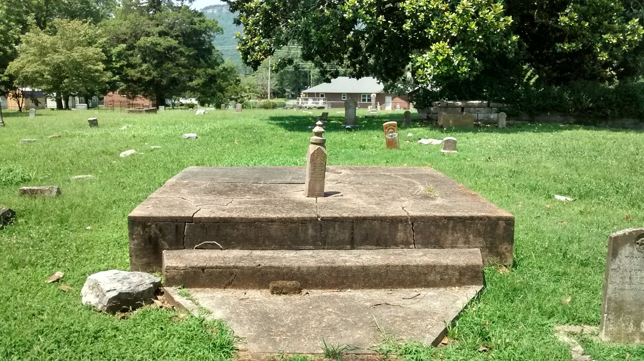
A polished metal sign marks the entrance to McNabb Cemetery in Marion County, Tennessee. Handmade. Unassuming. Like the place it protects.
Up this gravel drive sits McNabb Cemetery. The cemetery is older than Nickajack Dam, older than the power lines streaming down the mountain’s slopes, older than the idea that this valley would ever be engineered to harness electric power for the burgeoning population of nearby Chattanooga, Tennessee.
The earliest graves date back to a time when mines operated nearby, when families lived close to the land, and life followed simpler rhythms.
McNabb Cemetery follows design elements of other, nearby cemeteries like the one I have explored on Aetna Mountain, known as Aetna Mountain Cemetery.
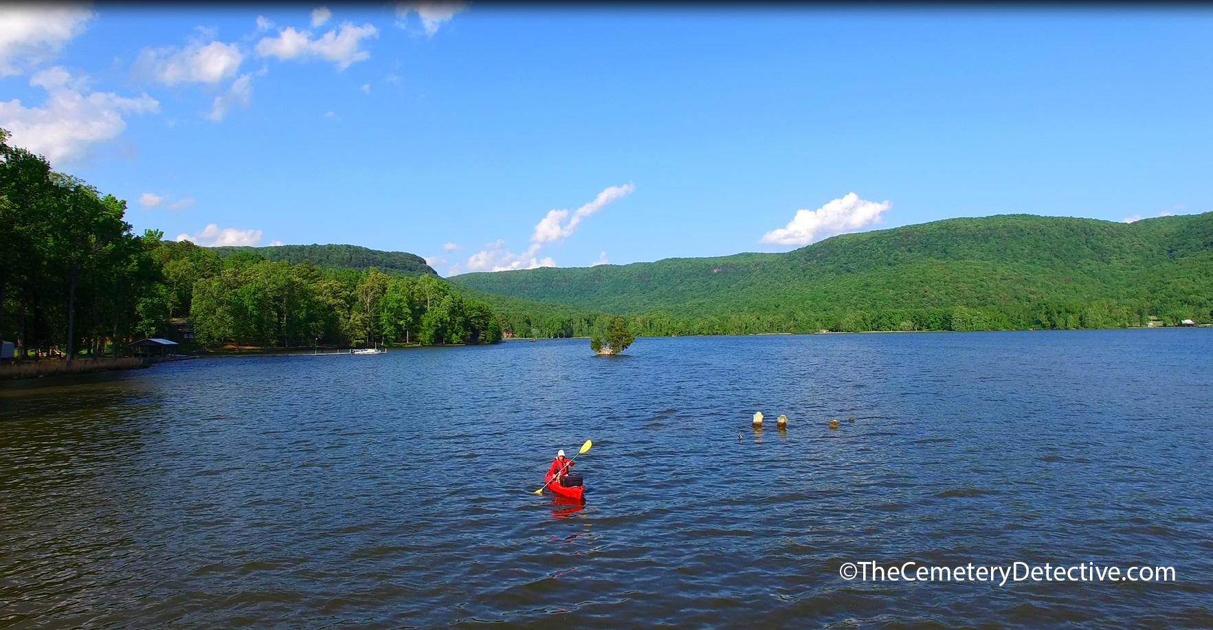
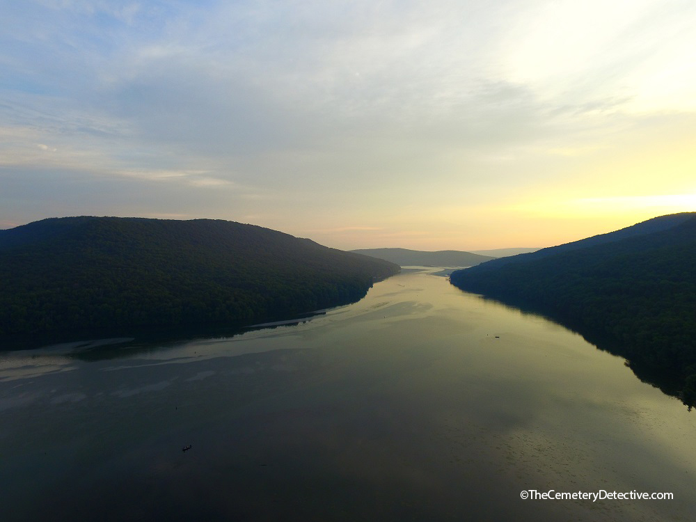
Nestled between the Tennessee River and the TVA Raccoon Mountain Pumped Storage Facility, McNabb Cemetery quietly watches two worlds pass by; one shaped by hand tools and hard labor, the other by turbines, storage tanks, and megawatts.
Here, time moves differently.
If you never owned a calendar, you could still tell the seasons by walking these rows. Spring brings flowers, freshly placed. Summer brings small flags and sun-faded ribbons. Autumn leaves collect around stones worn smooth by weather and years. And winter brings holiday decorations and the sound of cold rain falling onto the fallen leaves.
But time doesn’t stand still and progress moves ever forward. The burgeoning population of Chattanooga is spilling over, populating the nearby mountains and altering the natural scenery.
McNabb Cemetery lies on ground surrounded by TVA property which will act as a buffer zone to protect the encroachment seen by other cemeteries in the area.
According to TVA: “The area around Raccoon Mountain is a state-designated Wildlife Observation Area. The mountaintop is home to whitetail deer, woodchucks, gray foxes and, of course, raccoons. The most compelling wildlife attraction of the area is a large wintering population of bald eagles, which can be sighted from the overlook as they hunt in the woods and waters.”
Cemeteries like this aren’t frozen in the past; they’re living records maintained not by institutions, but by families who keep showing up.
Places like McNabb remind us that you don’t need marble to mark a meaningful life, and you don’t need a calendar to know when remembrance still matters.
Located in Red Bank, immediately adjacent to the city of Chattanooga, the Chattanooga Memorial Park Cemetery (originally known as White Oak Cemetery) sits atop rolling terrain that once served both agrarian land and Civil War strategic positioning. According to its publication, the cemetery “has been an important part of the community for more than 125 years.” Dignity Memorial+1 During my recent documentation trip I mounted a high‐resolution camera to my vehicle roof and captured a full drive‐through of the internal roadways while simultaneously logging GPS track data. This combined approach enables a temporal and geospatial documentation of the site, preserving how the landscape, stones, and pathways looked in 2025 for future researchers.
Historical Context: Community, Industry, and Landscape
In the late 19th and early 20th centuries the Red Bank and Chattanooga region grew rapidly due to railroads, wrought‐iron and steel manufacturing, coal and ore transport, and the expansion of urban Chattanooga as a regional hub. Many of the people laid to rest in this cemetery would have worked in the mills, on the railroads (including the Nashville, Chattanooga & St. Louis Railway), or in the supporting industries of the Tennessee Valley. At the same time, the location of the cemetery on higher ground above the river valley gave it both scenic appeal and symbolic permanence.
Originally designated as White Oak Cemetery, the property was described in local history thus:
“West of Hill City across Stringer’s Ridge … the Sawyer farm was acquired, and converted into a cemetery typical of those of the era.” Chattanoogan+2Dignity Memorial+2 In 1925 the name changed to Chattanooga Memorial Park after additional property was acquired. Dignity Memorial The grounds are described as being transformed into more of a park‐like setting (particularly after landscaping efforts by long‐tenured caretakers) with features such as a duck pond and mature trees, making the site more than simply a burial ground but also a place of community memory and quiet reflection. Dignity Memorial+1
Geology, Topography and Site Layout
The topography of the cemetery reflects the region’s geological and landscape context: elevated ridges, slopes down toward the valley, and underlying limestone or sedimentary bedrock typical of east Tennessee. While specific stone‐quarry sources for monuments may vary, the choice of stone material in many of the monuments corresponds with regional availability and economic status of the families buried there.
As the site moved from farm land (the Sawyer farm and White Oak Spring area) into a landscaped burial park, the internal roadways were laid out to follow natural contours rather than rigid grids. This “park cemetery” style meant that drives are winding, uphill and downhill, allowing views over the surrounding landscape and placing monuments on terraces or gentle slopes. This design approach enhances both aesthetics and circulation.
The inclusion of the duck pond and landscaping was an early 20th‐century enhancement. The water feature further demonstrates the blending of utility and beauty: gravesites tied into a park‐like environment rather than strictly a cemetery yard. Chattanoogan+1
My Temporal + Geospatial Documentation Effort
In line with the mission of The Cemetery Detective, my work at Chattanooga Memorial Park Cemetery followed a structured methodology:
Video Capture: Using a roof‐mounted high-resolution camera on my vehicle, I recorded a full drive‐through of all accessible internal roadways. This footage provides a continuous visual record of monuments, road surfaces, vegetation, signage, and overall condition of the cemetery at the date of recording (October 2025).
GPS Logging: Simultaneously I ran a dedicated GPS datalogger, logging positional data at high frequency (1-5 second interval). This produces a GPX track representing the exact route taken around the cemetery.
GIS Integration: After fieldwork, I imported the GPX track into QGIS (or ArcGIS) and with the future availability to overlay it with additional layers, such as:
Roadway polylines derived from the GPX track
Monument point layers (with attributes: material type, erection date, condition, inscriptions)
Special feature layers (duck pond, elevated ridges, park landscaping zones)
Temporal metadata linking frames of the video (via start time) to GPS coordinates. This allows for queries like “show all granite monuments erected before 1950,” or “highlight sections of the cemetery where road surface appears recently repaved or vegetation encroaching.”
Shareability & Future Use: By making these layers (GPX track, CSV/GeoPackage of monuments, and the video) available for download and archival, future preservationists, genealogists, and local historians can reference exactly how the cemetery looked in 2025, even as time (and weather, vegetation, development) inevitably changes the site.
Preserving Memory, Managing Change
Cemeteries like Chattanooga Memorial Park serve dual roles: resting places for individuals and collective memory landscapes for the community. The Red Bank/Chattanooga region continues to evolve with residential growth, infrastructure changes, and shifting maintenance regimes all affecting the condition and appearance of the cemetery. By providing a base-year documentation (2025) that is both visual and spatially precise, we create a benchmark against which future change can be measured.
For example: if in five years a major tree falls and damages monuments in a section; or if resurfacing alters the alignment of a road; or a cluster of older marble headstones begin to tilt, having a linked video + GPS + GIS dataset allows one to show exactly where and when change occurred.
Conclusion
My work at Chattanooga Memorial Park Cemetery in Red Bank/Chattanooga, Tennessee, is grounded in the belief that historic cemeteries merit the same precision of documentation as any heritage site. Through mounted video, synchronized GPS logging, and GIS layering, I am capturing a snapshot of this landscape as it stands in 2025. By doing so, we are able to honor not only the individuals interred here but the communities, industrial heritage, and topographic character that shaped the burial ground. Through these efforts conducted by myself and other cemetery enthusiasts, we equip future generations with a tool to monitor, research, and preserve this important piece of Chattanooga’s past.
Exploring Unique Burial Traditions in Southeastern Tennessee
On a recent cemetery exploration in Madisonville, Tennessee, I discovered two fascinating grave features: a Grave House and a Barrel-Vaulted gravesite. As part of my journey as The Cemetery Detective, I documented these rare burial structures, which offer insights into local traditions, historical preservation, and unique forms of grave architecture in Southeastern Tennessee.
The Grave House: A Structure of Protection and Respect
The Grave House, found in select cemeteries across the southern United States, was likely built to protect the deceased from the elements and animals. Built directly over two gravesites, this small structure resembles a miniature house, complete with a sloped roof and open sides surrounded by braided-wire fencing. Historians believe grave houses may have served as protective shelters, preserving the grave from weather-related erosion and wildlife interference. The symbolic significance of this structure may also act as protection to the gravesites, a continuation of the protection the house gave while they were alive on earth.
Although mostly found in Upland South cemeteries within Tennessee, Alabama, and Mississippi, I have found structures resembling Grave House in other parts of the country and the world. However, their designs vary with the regions within which they are found.
In Madisonville, this Grave House was well-preserved, displaying painted woodwork as evidence of care by descendants or the local community. As I captured this on video, I couldn’t help but reflect on how this regional tradition may provide grieving families a unique way to memorialize their loved ones. The structure itself and the maintenance of the structure both physical protection of the gravesites and a lasting tribute to the memory of the deceased.
The Barrel-Vaulted Grave Covering: A Unique Architectural Style
Immediately adjacent to the Grave House, I discovered a rare Barrel-Vaulted gravesite. Unlike traditional flat or angled grave covers, this barrel vault is a rounded arch structure, crafted from red bricks covering the entire length of the grave. This distinctive mounded design may be inspired by European grave architecture. I have seen similar structures in my travels in Spain and Italy
Barrel-vaulted graves reflect an era when grave-building involved extensive masonry work, often at a significant cost of money and time to the family. In addition to its structural integrity, this vault shape may also signify a spiritual “vaulting” over the deceased, a notion possibly rooted in religious or cultural practices. It’s rare to find such an intact example of this barrel-vaulted grave covering design.
Preserving Historical Grave Sites
As I document unique gravesites and burial practices, it’s essential to recognize the importance of preserving these structures as well as the lives and the memories of the people they protect. Grave Houses and Barrel Vaults represent a tangible connection to past burial traditions and offer valuable insights into the customs, religious beliefs, and aesthetic preferences of earlier communities. By sharing these discoveries on The Cemetery Detective, I aim to raise awareness of these historical markers and the stories they hold.
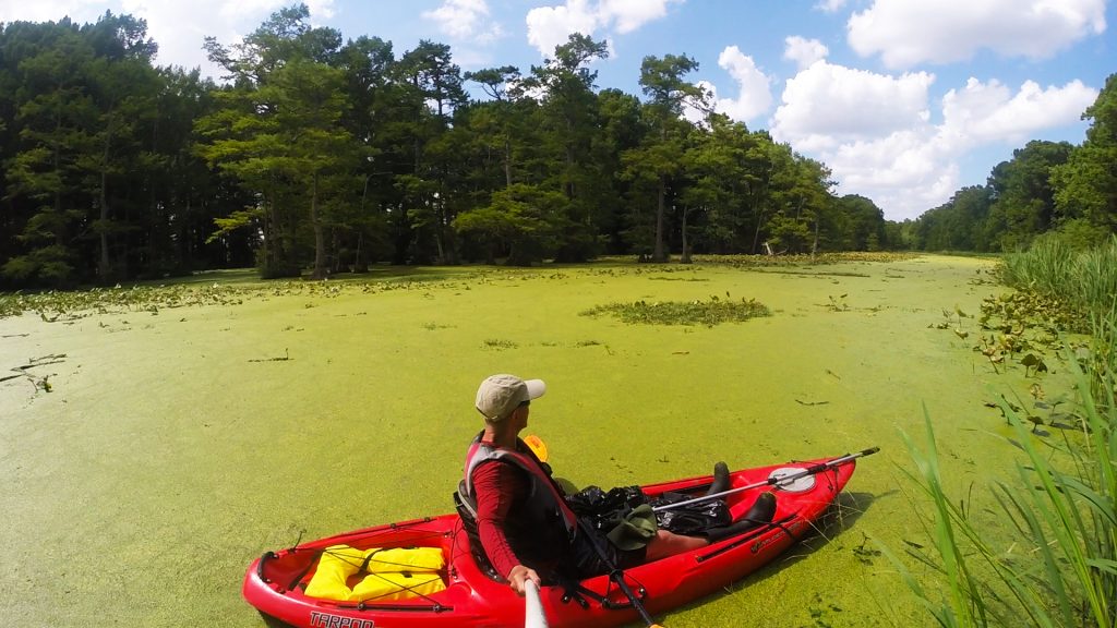
A mid-summer road trip to explore cemeteries of Western Tennessee turns into an adventure on Reelfoot Lake.
Reelfoot Lake – Western Tennessee.
For a couple days during the July 4th week, I took my kayak to Lake County, Tennessee in the extreme North West reaches of the state. I was in the area to explore cemeteries near the shoreline of Reelfoot Lake. Reelfoot Lake was formed during a succession of earthquakes from late 1811 to the big quake that occurred February 7, 1812.
The Natural Beauty of Reelfoot Lake
Many areas of Reelfoot Lake are swamp-like. Bald Cypress pierce the surface growing skyward 100 feet. I kayaked shallow water beneath the cypress’ darkening canopy. Searching for Water Moccasins and Broad-banded Water Snakes, I felt uneasy fantasizing of my reaction should a snake drop from a tree and hitch a ride in my kayak. I love wildlife in areas like this; Osprey, Eagle, Egret, Turtle, and Dragonfly by the hundreds. My favorite wildlife encounters on this day were the two large beaver dam I found in a far removed remote section of the swamp. As I paddled right up to the 2nd beaver dam, I heard beaver grunting and working and gnawing tree branches inside their den.
After 3 hours paddling alone and without seeing another human soul in the swamp, I decided to turn back in advance of a threatening afternoon thunderstorm. I like to think I have a pretty good sense of direction but the myriad bayous and narrow reedy marshy paths I had explored mishmashed in my memory.
Lost In A Swamp
“Oh no! I’m lost!” As I paddled furiously searching for the boggy opening in the treeline where I launched my kayak early that morning, I heard cracks of thunder immediately behind me. “Where is that opening? Where is my van? I think I recognize that osprey nest. That tree looks familiar. Is that turtle the same turtle I saw this morning? WHERE IS THAT OPENING?“
I paddled for a good 45 minutes toward the direction where I thought I had left my van hours before. Each inlet looked the same as the last inlet. Midsummer heat and sunshine caused algae blooms to fully cover the swamp’s surface. Distinguishing features softened into a continual undulation of never-ending shoreline.
“I’m never going to make it out of this swamp. They’ll have to send a search party but they’ll never find me. I’ll be consumed by the swamp. Devoured by turtles and osprey and water moccasins. I wonder who will play the lead character in the movie they’ll make about this. WHERE IS THAT OPENING?“
With enormous black clouds overhead and raindrops beginning to fall, I had to admit I was lost. My personal stark realization of my inability to find my way out of this endless swamp consumed me with each stroke of my paddle. Heavy in my hands, I laid my paddle across my lap to rest my weary arms. My kayak ground to a halt from friction of the thick…thick surrounding vegetation.
Finding My Way Out
I dipped my hand through the vegetation to make contact with the water below. Expecting refreshing cool, I was met, instead, with emanating heat from the lake’s surface. I didn’t even think what might lie beneath. A giant Alligator Snapping Turtle? A Muskrat with gnarled, sharpened teeth? The Water Moccasin I’d been seeking for hours? Pulling my hand back into my kayak, I reached for my water bottle. I had plenty of fluids left but any ice I had brought with me had long since melted in this blistering July heat.
With reluctance and a final admittance that I could not find my own way out of the swamp, I reached into my dry-sack for my trusty GPS. Luckily, I had set a waypoint of my launch point when I first set out early in the morning. According to the graphic on the electronic map, I was less than 1/2 mile away. A quick paddle through thick mats of aquatic lilies had me back at my launch point in a matter of minutes. “Ah, there’s my van….cool.”
I never did find any Water Moccasins but I sure was happy to be back on dry land.
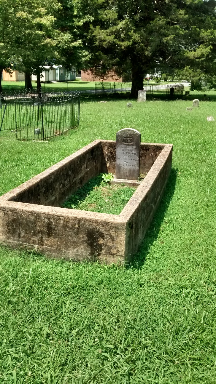
No matter how small. How old. In what condition they’re in.
No matter if they are in well maintained cemeteries.
Or ones that have been neglected.
No matter if the grave is of someone with whom we identify.
Or someone of a differing cultural belief.
All gravestones represent a life once lived.
And, as such, all gravestones matter.
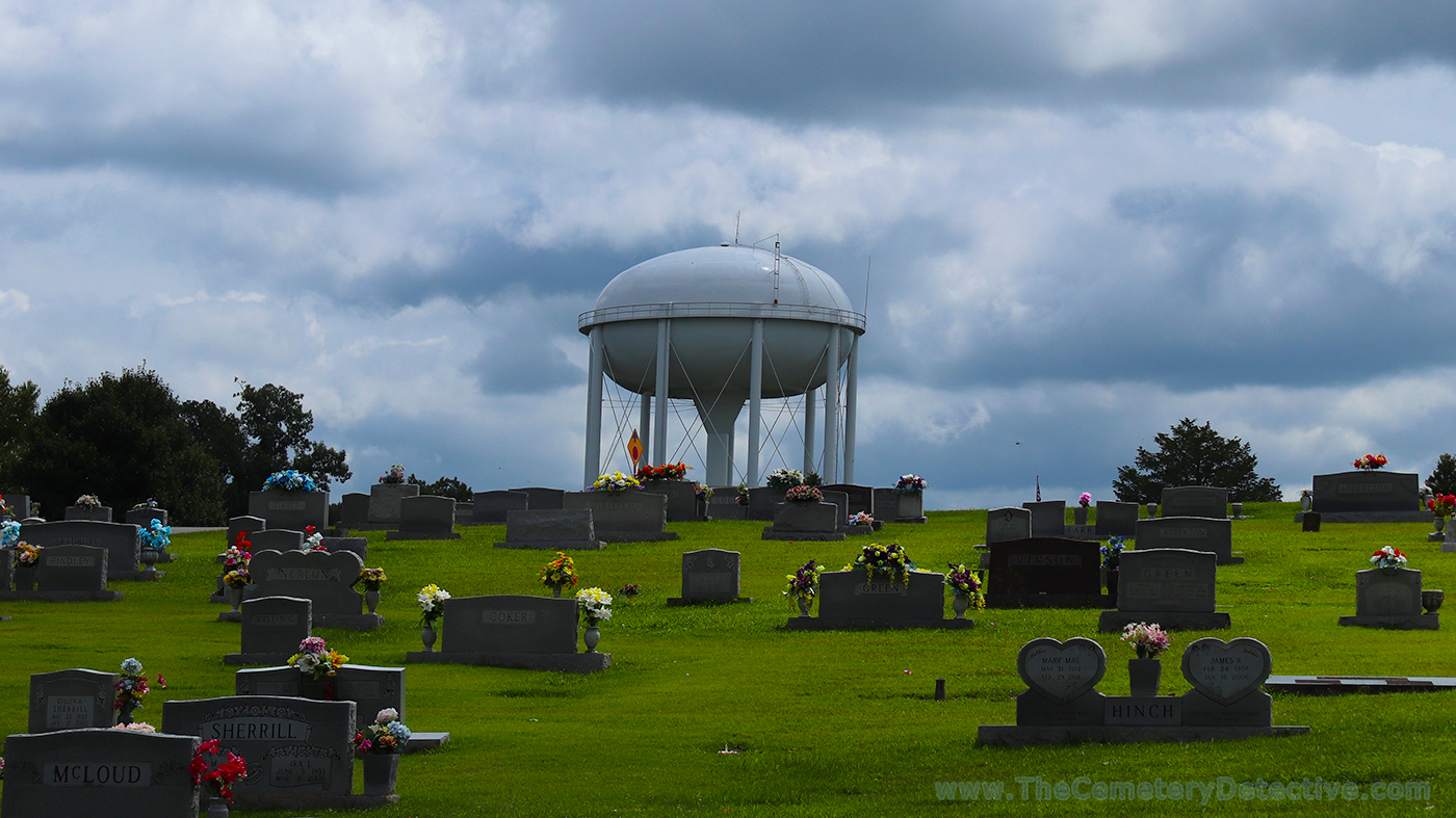
A water tower overlooking a cemetery adds a whole new dimension.
Cemetery and Water TowerI’m pretty sure I have a new fascination…water towers over cemeteries. I’ve seen quite a few, recently. I found this one while researching cemeteries around the “world’s largest tree house” also known as “The Minister’s Treehouse.” (link below).
I cannot see a water tower without thinking back to a version of the War Of The Worlds movie I saw on TV when I was a kid (maybe it was a rebroadcast of the 1953 film?) where a farmer shoots a water tower mistaking it for a martian.
Now, seeing water towers over cemeteries adds a whole new dimension.
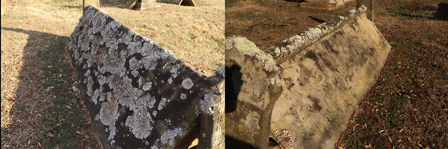
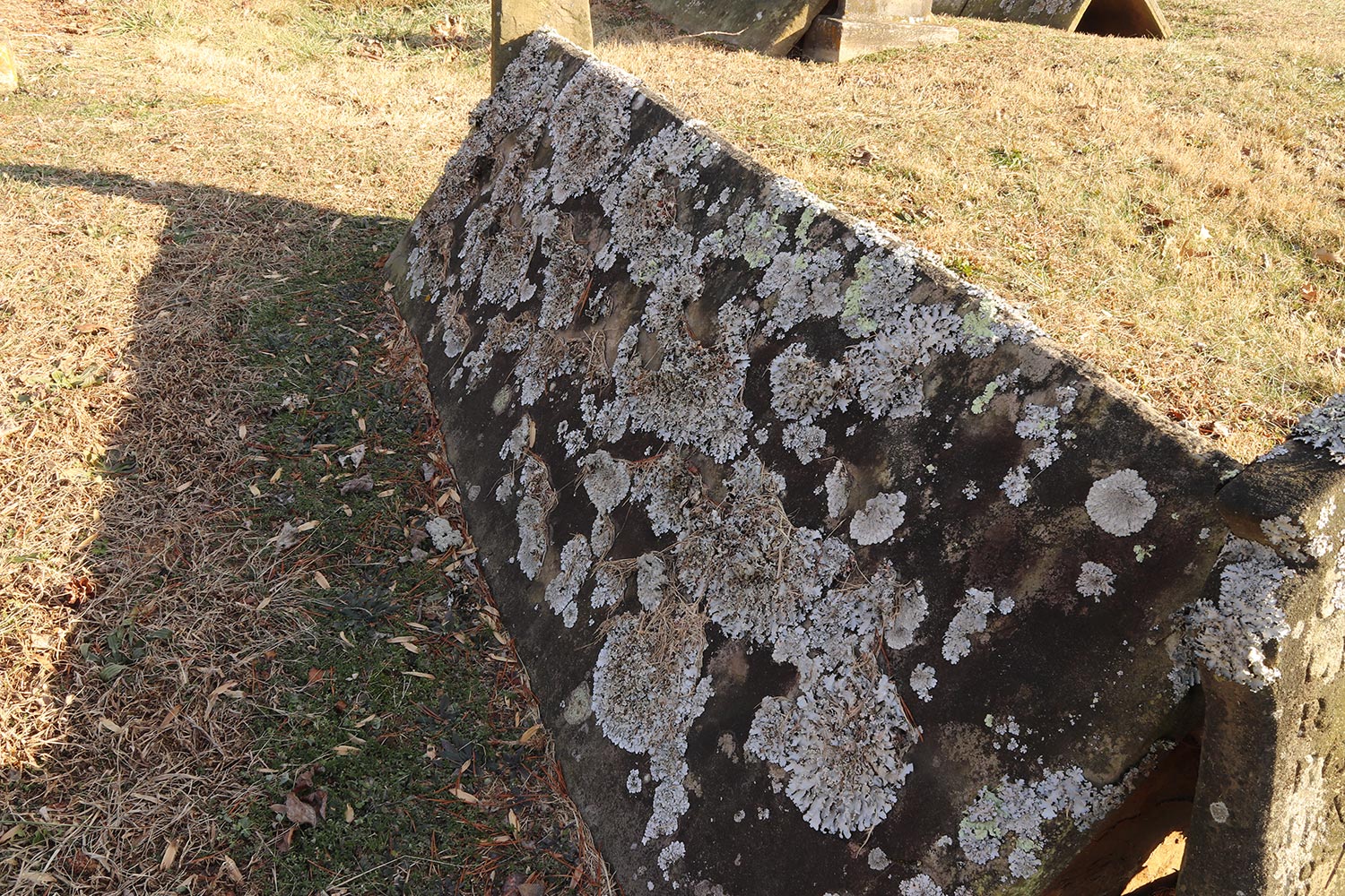
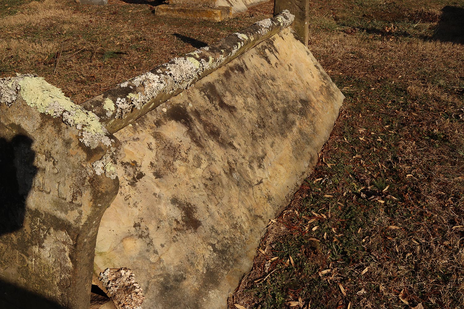
I’m almost embarrassed to admit I’m pretty fascinated with lichen growth on gravestones.
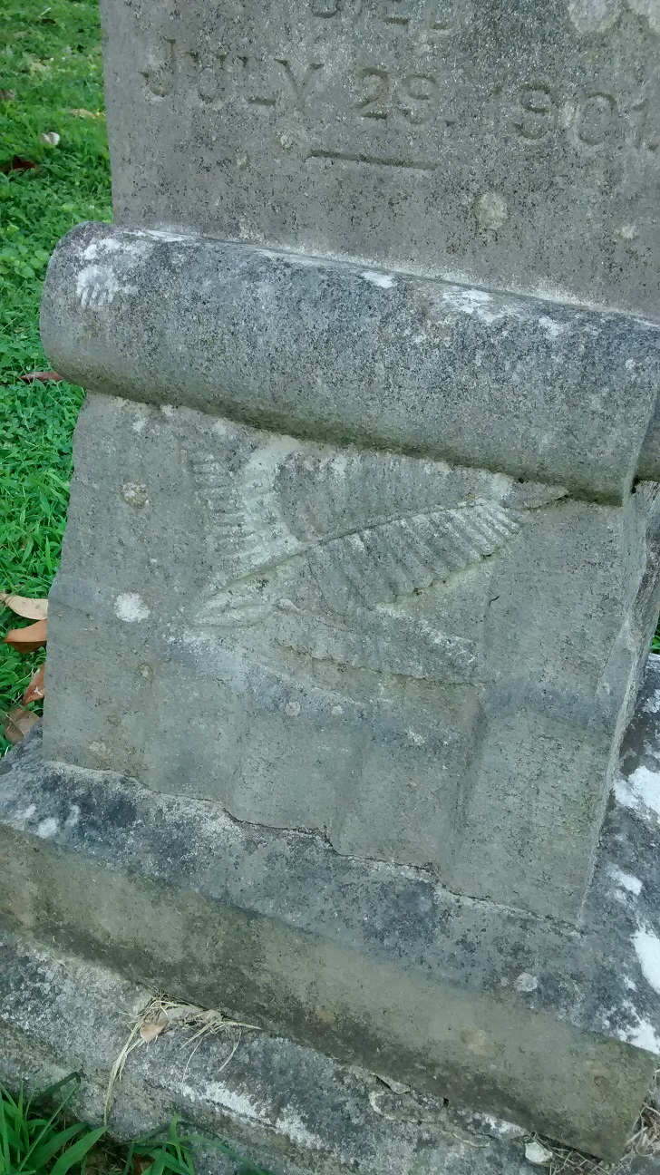
During my visits to study comb graves of the Cumberland Plateau, I encountered quite a few comb graves with West-East orientation. Of course, you would expect this. It is very common for bodies to be buried with their feet toward the East. The reasoning behind this is when the rapture occurs, the body will rise up facing eastward toward the coming of Christ.
Because of this orientation, the right sides face south and the left sides face north. Remember back in elementary school (Boy Scouts and Girl Scouts) when you learned that moss gross on the north sides of trees? The same is sometimes true for gravestones.
You normally don’t see a drastic difference of lichen on the north vs. south side of a gravestone. However, since the roofs of Comb Graves are slanted, the north sides receive quite a bit less sunlight throughout the year allowing lichen to, more readily, grow.
Here is one example of lichen growing on the north side of this comb grave (left) vs. almost no lichen growth on the south (right) side.
What constitutes a cemetery? Do you ever think about the idea of a burying ground that transcends the strict and cultural definition of a traditional cemetery?
A 400 Million Year Old Cemetery?
What constitutes a cemetery? I understand there are legal classifications and procedural definitions. But, do you ever think about the idea of a burying ground that transcends the strict and cultural idea of a traditional cemetery?
Is a pet cemetery actually a cemetery? If humans designate land where they bury their pets, it certainly fits my definition of a cemetery. Is human interaction needed for it to be considered a cemetery? I’ve read about elderly elephants who are aware they are going to die. They migrate to ancient elephant graveyards where their relatives come to mourn their passing. There are no humans to designate this as a cemetery…but the elephants think it’s one. What about pre-historic graveyards; the final resting places of beings that lived millions of years ago? Is it unreasonable to stretch our imaginations by exploring the far reaches of what, actually, constitutes a cemetery?
Sometimes, I enjoy contemplating the actual definition of a cemetery. One of these internal contemplations happened on a trip to explore Cowan Cemetery.
Cowan Cemetery
I recently took a trip to Meigs County, Tennessee to visit Cowan Cemetery. This cemetery dates back to the 1850’s as a cemetery for Cowan family members. There are many fieldstones here denoting unnamed gravesites. A few of the fieldstone markers are hewn into triangular shapes. Though not perfectly angled, they remind me of endstones from tent gravesites found in some Tennessee cemeteries and other cemeteries in the southeast. One grave marker displays fantastic “Hand of God” symbology. The hand, clutching lilies and roses, is downward facing with an outstretched pointing index finger.
Cowan Cemetery is a short paddle away from an area known as Rattlesnake Point. Rattlesnake Point is where my Father’s family used to hold their yearly family reunions on the banks of the Hiwassee River. The Hiwassee River is a tributary of the Tennessee River. Its unique geology makes for joyful fossil hunting. I spent those family reunions searching for fossils on the banks of the Hiwassee river. I clearly remember the first time I found a fossil. Though my family wasn’t at all interested in my explorations, I fantasized that I would be recognized as a great dinosaur fossil hunter by the scientific community.
Fossilized Rock
In reality, the fossil I found wasn’t from the Dinosaur era. Instead, it was filled with Brachiopod fossils from the Devonian period. This geological period dates back 400 million years; long before Dinosaurs appeared on earth.
I often think back to my first fossil find and its influence on my interest in cemeteries. When you think about it, that rock is similar to a cemetery in that it is the final resting place for hundreds of beings. It’s kind of like a cemetery; a 400 million year old Brachiopod cemetery.
Research of one cemetery leads to questions about another cemetery.
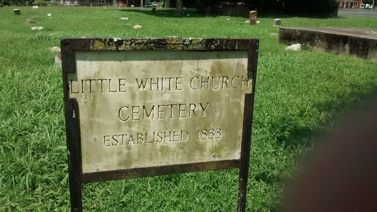
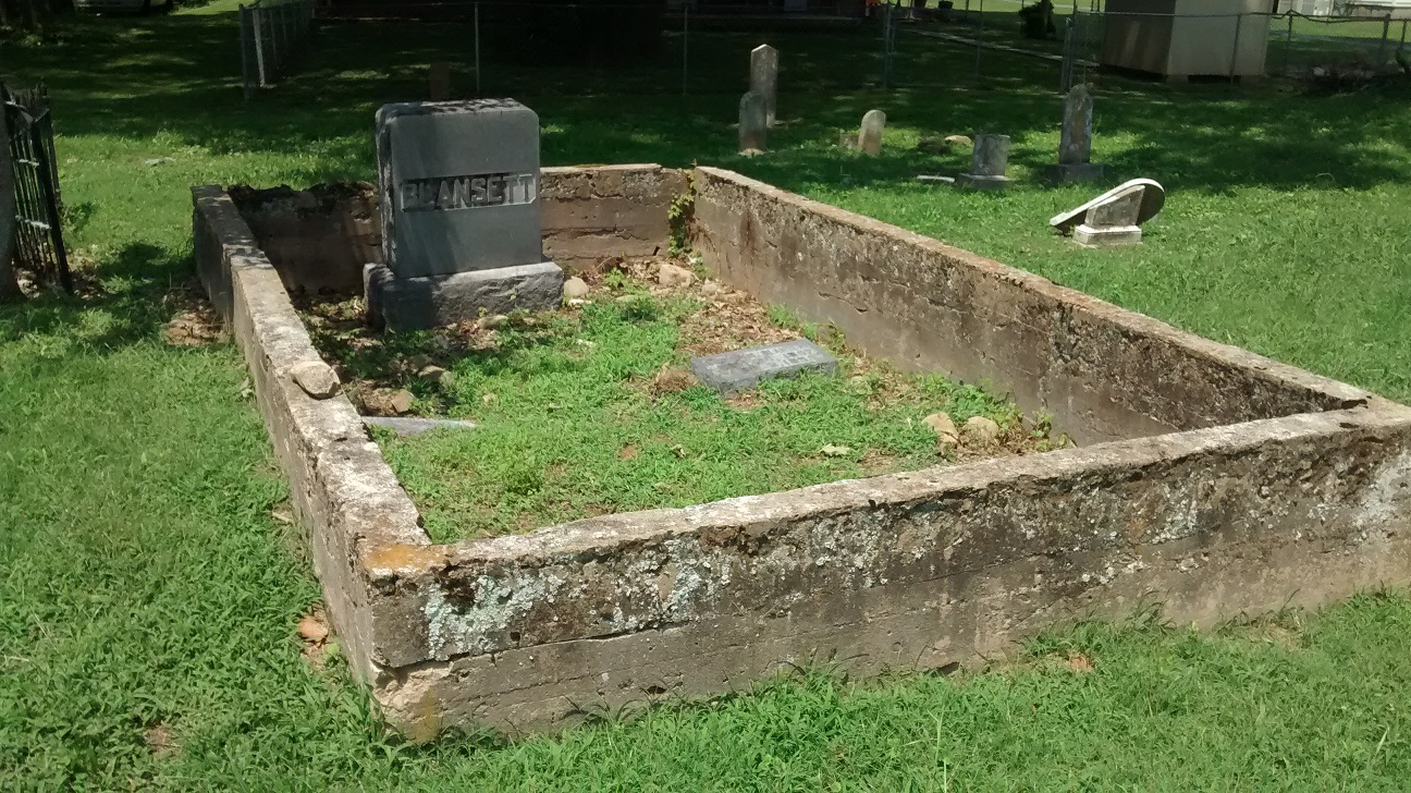
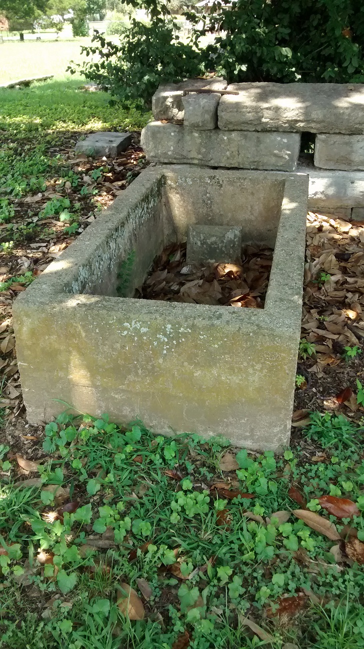
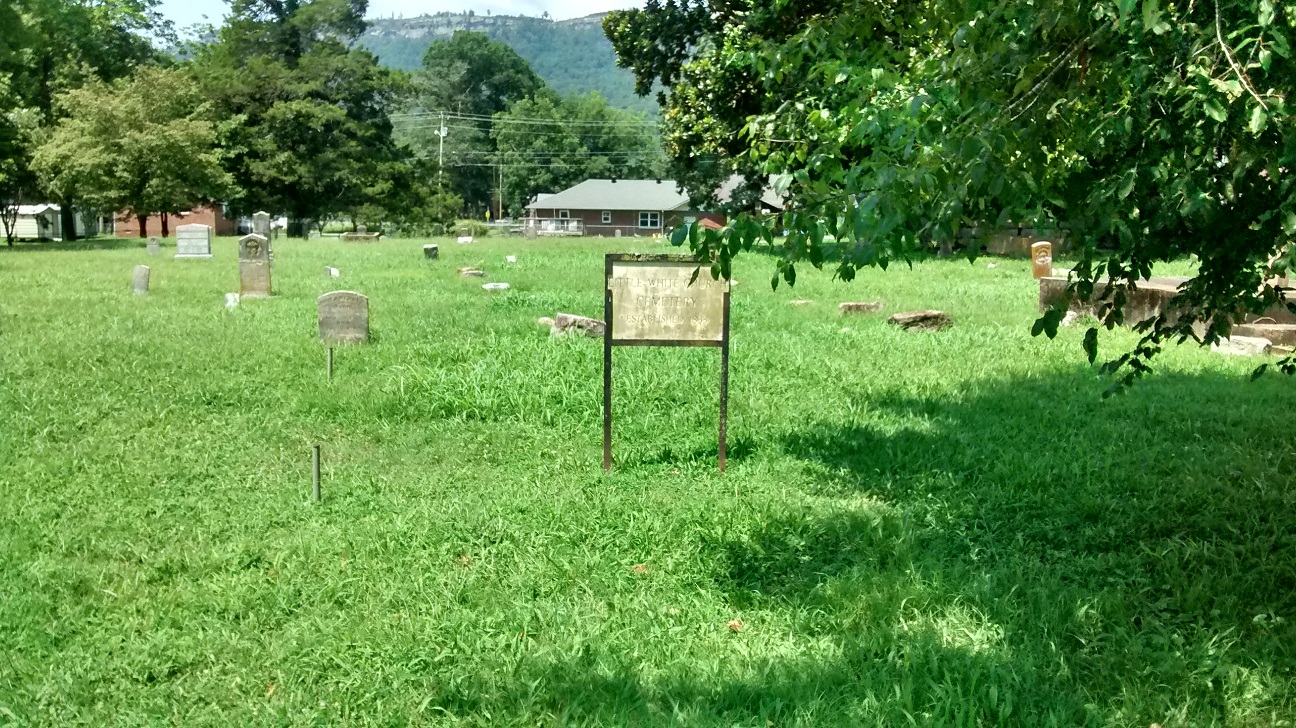
While visiting the Jasper, Tennessee library to research my Submerged Cemetery Documentary, I found Little White Church Cemetery just across the parking lot.
It was a sweltering July afternoon and I almost opted for my car’s welcoming air conditioning instead of trudging across the asphalt to view the grave plots. As is normally the case when I think I won’t find anything interesting, I found a cemetery full of grave sites encompassed by 18″ to 24″ concrete walls.
I’m sure I’ve seen this type of design before. However, I’m confused of its purpose and functionality. Is the high wall design intended to keep people and grazing animals from walking on the grave? Do the walls prevent potential erosion problems?
This cemetery is well maintained. The grass was long on the day of my visit. However, it is certainly being cut on a regular basis. Do these walls inhibit proper mowing maintenance? It takes a lot of work to mow grass in a cemetery. I imagine the lawn mowing guys either use a weedeater inside the grave enclosure or lift a small push lawn mower over the walls to perform their mowing. I do wonder if small animals (including snakes) accidentally fall inside the cordoned off perimeter and find themselves unable to escape.
Despite the heat of this blazing hot late July afternoon, the trip to Little White Church Cemetery sparked a curiosity about these grave walls.
If any of my readers know the purpose or history of these grave plot walls, please leave a comment below or send me a private message.
The Submerged Cemetery at Mullins Cove
commonly referred to as: Long Cemetery #2
The Submerged Cemetery at Mullins Cove
By 1807, Henry Long was living in Jonesborough, Tennessee after moving from Virginia. But, Henry wasn’t satisfied living in Jonesborough. His sights were set deeper into this newly formed state. Tennessee had been admitted into the Union only 11 years earlier. Opportunities here were plentiful.
Henry Moves to Mullins Cove
Henry, along with two companions, boarded a crudely designed raft. They were swept past the confluence of the Holston River and French Broad River. These two rivers form the headwaters of the Tennessee River. Of course, back in those days the river was still known by such names as The Hogoheegee and The Great River of the Cherokee.
Confluence of the Holston and French Broad Rivers
This was an unmanaged river. There were no dams back then to stem its flow. The river flooded with spring rains and nearly dried up with summer droughts. Henry navigated his craft downstream past Knoxville and Chattanooga. Chattanooga was a Cherokee trading outpost at the time.
Henry initially settled in the Sequatchie Valley where he operated a successful Livestock Trading Business.
Mullins Cove – Marion County, Tennessee
By 1811, Henry and his new bride Zilpha moved to an area of Marion County known as Mullins Cove where they acquired 2000 acres. From the tall mountaintops down through the fertile bottom land they hacked their way through thick canebrake that inundated their land. Here, they successfully raised a family and continued with their stock trading operations.
Mullins Cove (in the distance) from the Tennessee River
Zilpha Buried in a Cemetery on Dry Land
Zilpha passed away in 1860. She was buried in a small cemetery on their land. This cemetery was on a slight hillrise about 1/4 mile from river’s edge. Henry died in 1875. He was buried alongside Zilpha. As generations came and went, some of their descendants were buried there, too. For example, Henry and Zilpha’s great grandson Moses Merritt Long was buried in the cemetery in 1881 after dying at only 3 months of age.
The land stayed in the family but big changes were coming to this area. There was a need for improved river navigation. There was also a need for electricity for the burgeoning population of Euro-Americans who were streaming into the area.
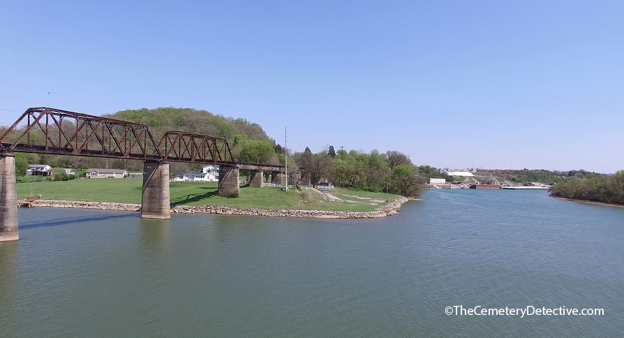
Hales Bar Dam on the Tennessee River
By 1905, Chattanooga businessman and engineer Josephus Guild had begun construction of the first multi-purpose hydroelectric dam built across a navigable waterway by private industry. His company, The Chattanooga and Tennessee River Power Company devised this dam for a two-fold purpose. The dam would improve river navigation along a treacherous stretch of river known as the Tennessee River Gorge and it would also provide electric power to the burgeoning population of Chattanooga, Tennessee. This dam was located across Hales Bar; about 5 miles downstream of the cemetery.
A Cemetery Underwater
By 1913 Hales Bar Dam opened for operations. The lake level behind the dam rose to 626.2 feet MSL (above Mean Sea Level). By the 1920s, The Chattanooga and Tennessee River Power Company had merged with several other companies to form a new company called Tennessee Electric Power Company (TEPCO). TEPCO desired to increase the operating capacity of Hales Bar Dam by fastening flashboards across the crest of the dam. These flashboards raised water levels in the upstream lake by an additional 3 feet to 629 feet MSL.
Hales Bar Dam Powerhouse
It is unclear whether lake waters were lapping at the cemetery’s perimeter at this time or if the cemetery was already completely under water by the 1920s.
As it stands today, the ground surface of the cemetery appears to be approximately 631′ MSL. However, mechanical action of river currents cause silt to move from upstream locations toward downstream locations where natural collection occurs. The damming of the river caused this silt to collect in such areas as Mullins Cove. Considerable silting has taken place over the decades. Because silting raises ground levels, it is entirely possible the cemetery’s elevation was lower in the 1920s than it is today. This means the cemetery might have already been flooded in the 1920s after the lake level was raised to 629′ MSL.
Tennessee Valley Authority – Hales Bar Dam
In 1933, The Tennessee Valley Authority came into existence. Plans were quickly devised to acquire Hales Bar Dam. By 1939, after that transaction was complete, TVA owned and operated the dam.
TVA had bigger plans for Hales Bar Dam. As part of TVA’s mission to further improve navigation along the Tennessee river, TVA sought to deepen the navigation channel between Hales Bar Dam and the newly built Chickamauga Dam 33 miles up stream. Prior to 1946, the minimum depth of water upstream to Chickamauga Dam was 6′. However, a 9′ minimum depth was required for large steamers and barges operating in the area. Between 1946 and 1949, TVA increased Hales Bar Dam’s operating pool. Lake levels were raised by an additional 5 3/4′ allowing for improved navigational depths all the way upriver to the foot of Chickamauga dam.
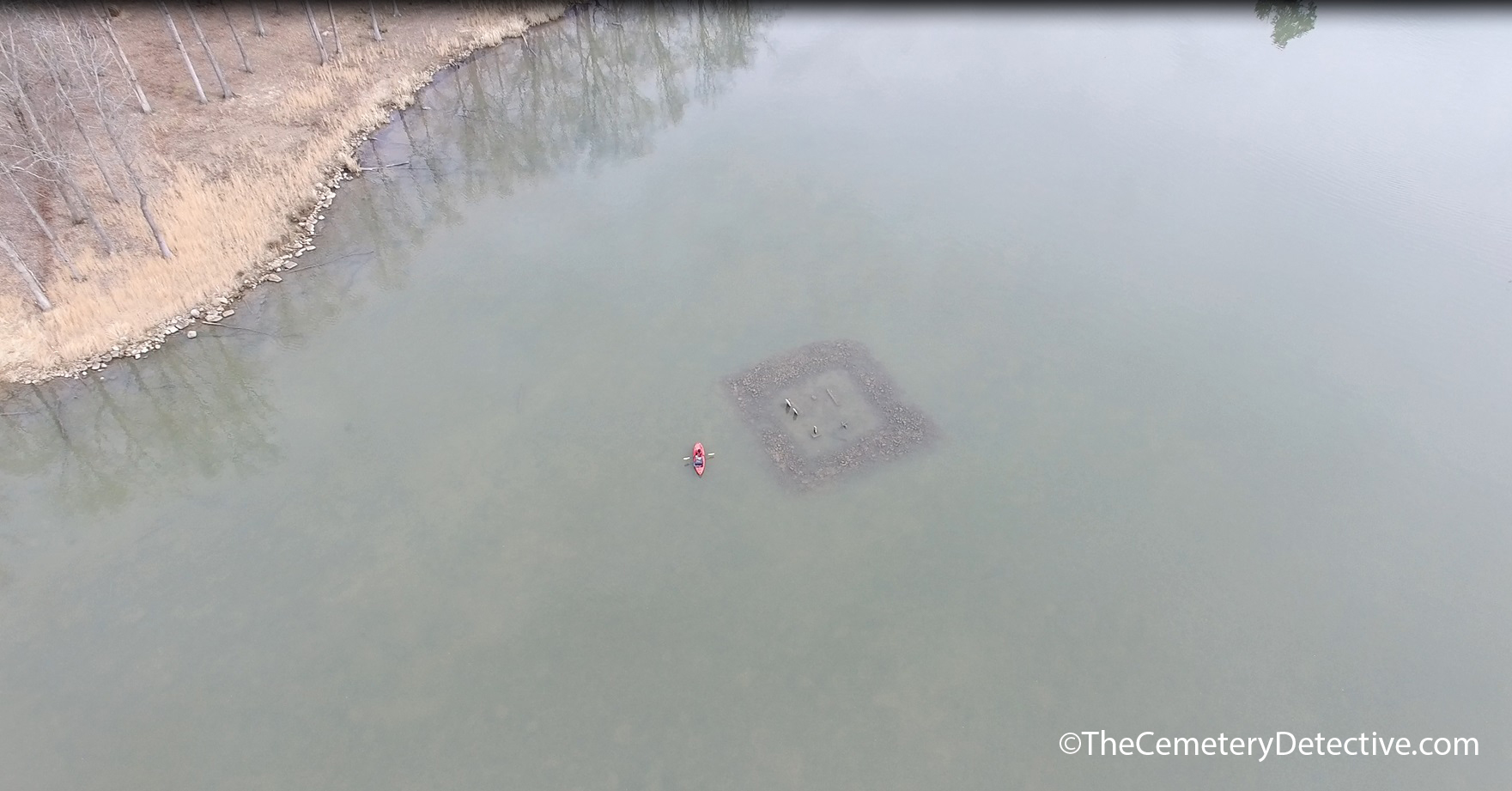
The Submerged Cemetery at Mullins Cove
With the raising of lake levels an additional 5 3/4′ to approximately 634′ MSL, the cemetery was most certainly underwater by 1949 even if it hadn’t been underwater beforehand.
Cemetery Relocation Strategy
TVA has a structured cemetery removal procedure. When TVA builds a dam, they perform an environmental impact study. One component of this study is a search for cemeteries in affected areas. If a new dam is to cause a cemetery’s flooding, TVA will seek family consideration as to whether or not the cemetery or individual grave sites will be moved to an appropriate location. If family members of those buried in the affected cemetery wave the right to have the grave sites moved, TVA respects the family’s wishes. If family agrees to a removal, TVA develops a plan for a respectful relocation of affected grave sites. In fact, TVA has relocated grave sites from more than 550 cemeteries within their river system since their inception in 1933.
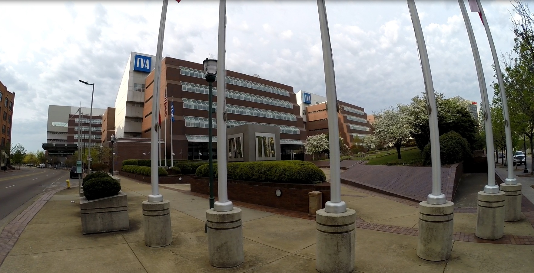
TVA offices in Chattanooga, Tennessee
However, the submerged cemetery at Mullins Cove is a special case.
According to TVA officials, this cemetery was flooded prior to TVA’s involvement with Hales Bar Dam. Because of this, TVA seems to defer to perceived prior agreements that family members would have made with TEPCO.
Superseding the already mentioned reasons why the grave sites were not moved, there is evidence of a 1944 agreement with Long Family descendants. This agreement supposedly provides that the grave sites should remain in place. (I have not, yet, acquired an actual copy of this agreement. I will update this information should I acquire this agreement.)
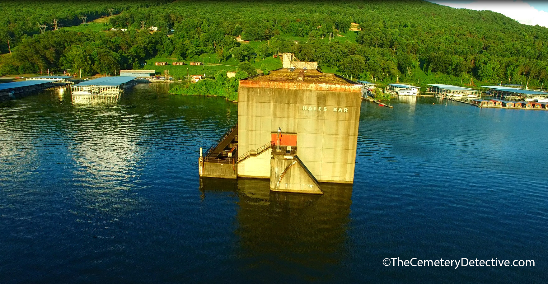
Hales Bar Dam Failure
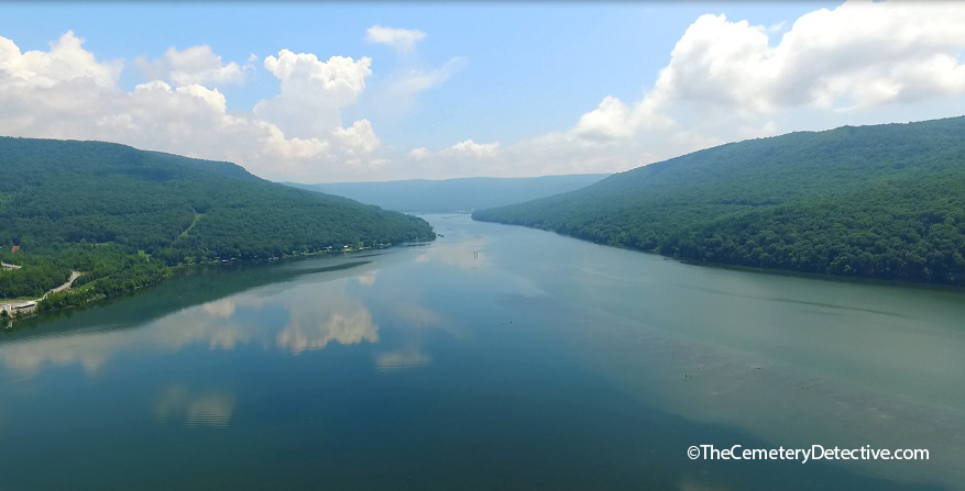
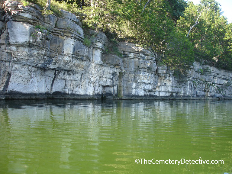
When the Chattanooga and Tennessee River Power Company drew up plans to build Hales Bar Dam, they performed many topographical studies. However, significant geological studies were not performed. If current geological models had been available in 1905, engineers would have realized Hales Bar contains a bedrock of Mississipian Age Bangor Limestone. This particular type of Limestone is very susceptible to water erosion and development of subterranean karst formations. The karst formations in the area of Hales Bar form a fractured, cavernous system on and below the riverbed. Hales Bar Dam was built on a faulty foundation. On the very day after Hales Bar Dam filed it reservoir, engineers noticed water bubbling downstream of the dam. The dam was leaking due to the fractured bedrock.
Limestone Was Hales Bar Dam’s Undoing
This leakage was a known problem at the time of the dam’s acquisition by TVA. However, TVA thought they had a solution. Pumping grout into the internal structure of the bedrock would surely plug all the holes and prevent further leakage. Although this repair held, initially, leaks soon returned. At its worst, water was flooding under the dam at a rate of 2000 cu. ft./second. The loss of water was so great that the dam had trouble generating electric power because there was not enough overspill to turn the turbines.
Nickajack Dam Replaces Hales Bar Dam
TVA worked for two decades to repair this problem. By the 1960s, TVA deemed the dam economically unviable. TVA proposed a plan to build a replacement dam 6 miles down river in a more geologically hospitable segment of the Tennessee River. This dam is called Nickajack Dam.
Nickajack dam opened in 1967 and remains in operation today. By September 1968, Hales Bar Dam was dismantled allowing for free river navigation across Hales Bar. Nickajack Dam maintains lake levels at approximately 633 feet MSL give or take a foot or two on a daily basis.
Therefore, the cemetery is at, or very near, surface level year-round.
Although the dam at Hales Bar is no longer in existence, a section of the old lock system and remnants of the powerhouse are still visible.
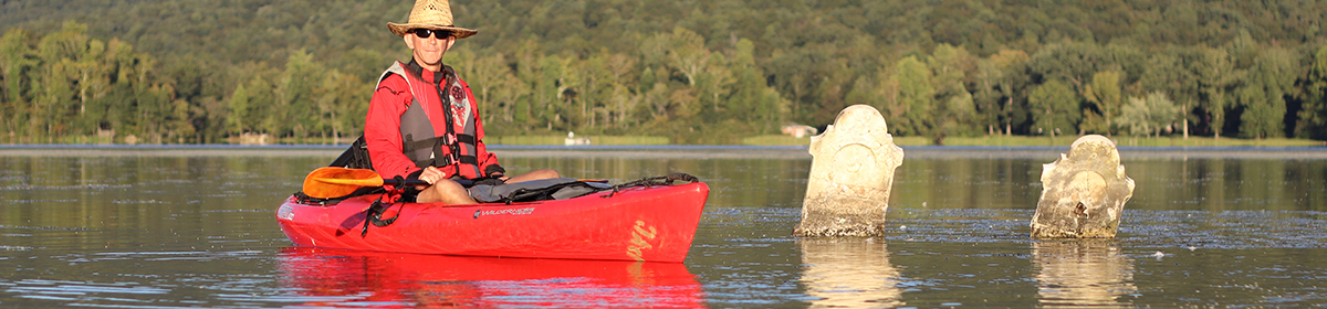
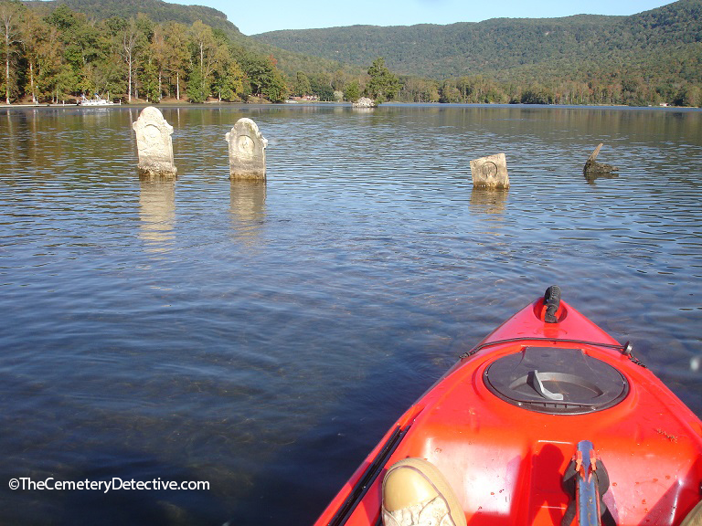
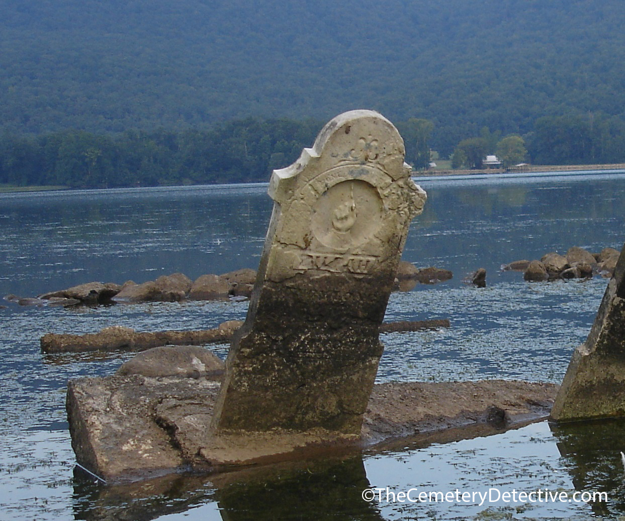
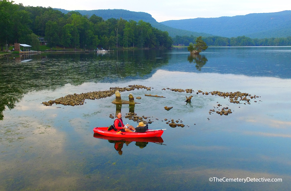
Zilpha’s Gravestone in Mullins Cove Cemetery
When I began researching the cemetery at Mullins Cove, I found news articles claiming Henry, Sarah, and their child Moses were buried there. However, this just did not check out with my genealogical research.
Although there was a Sarah on the family tree, it did not make sense that Henry would be buried right next to Sarah who was his daughter-in-law.
Initially, I was confused that Henry would be buried next to his daughter-in-law. As I continued to study the gravestones, I discovered that it was not Sarah buried here but was, in fact, Zilpha. The news articles I had read (and still continue to find) made a mistake about this grave site and gravestone.
The Submerged Cemetery at Mullins Cove
The years have not been kind to Zilpha’s gravestone. It is almost illegible even in the best of visibility and at times of low lake levels. It is especially difficult to read when the sun is overhead. Many of my first visits to the cemetery were during morning or afternoon hours. However, during these visits, I could never get a truly good read of the inscriptions on the three gravestones. Lighting makes a huge difference in my ability to read a gravestone. So, during late summer of last year, I began visiting the gravestone during the evening hours when the sun was setting just behind Stoker Ridge in an area of the Tennessee River known as Bennett Lake.
The setting sun helps me read gravestone inscriptions
Now, I need to sidetrack for just a moment to make a point of interest. I normally try to start my day early and visit cemeteries in the morning hours. This time-of-day gives me the best chance of reading inscriptions. A tradition in Upland South cemeteries is that gravestones often face east. Therefore, the rising sun illuminates inscriptions of gravestones. Early morning light makes them easier to read. However, the gravestones in the Mullins Cove cemetery face west.
TVA Fixes Headstones and Protects Long Cemetery
I have no documentation on the original orientation of the gravestones. However, in 1999, in a response to public outcry, TVA righted the gravestones at the same time they built a protective fence of riprap around the perimeter of the cemetery. The gravestones had been tilted for years. Whether or not the gravestones originally faced east is unknown. However, when the gravestones were righted, they were placed facing west. Now, personally, I like the fact that they are facing west. High hilltops rise directly east of the cemetery’s location. Therefore, the face of the early morning rising sun never truly illuminates the gravestones. However, by late summer, when the sun is beginning to move southward on the horizon, its angle as it sets over Stoker Ridge is low enough that the face of the gravestones are aglow with deeply rich September sunsets.
September’s setting sun allows for better reading of all three gravestones. When I began scrutinizing their inscriptions, I slowly realized news accounts of Sarah’s burial here are inaccurate. Zilpha is buried here, not Sarah. There is a curious thing about Zilpha’s gravestone. Zilpha spelled her name ZILPHA. However, the last two letters in Zilpha’s name are transposed AH instead of HA. Since the gravestone is difficult to read, a cursory glance at the last two letters could lead someone to believe that SarAH is buried here. I surmise that someone misidentified the gravestone years ago. Now, when a news agency reports on this cemetery, the misinformation is regurgitated.
After intensive study with many different angles of sunlight and many levels of lake water, I have been able to determine the writings are as follows:
ZILPAH [sic]
wife of
HENRY LONG
BORN
Sep 22 1792
DIED
Oct 04 1860
HENRY LONG
BORN
May 16, 1782
DIED
SEPT. 16 1875
Moses M.
Long
1880 – 1881
According to my genealogical research, Moses Merritt Long is very clearly Henry and Zilpha’s Great Grandson, not Henry and Sarah’s child as some news agencies have reported. Since Moses is buried here, I have often wondered if his parents are also buried beneath the water’s surface.
Aerial Cemetery Photography
Using an aerial videography platform, I have surveyed the entire lake bed in the area of the cemetery looking for other grave sites. Even when lake levels are at their lowest, there are no other apparent submerged grave sites. However, during one of my early scans, I found another cemetery several hundred yards away in a wooded plot on dry land. After paddling to this cemetery, I found many Long family descendants including Moses’ father, James Long. However, there is no sign of Moses Mother, Rhoda Emma Greer Long.
The Submerged Cemetery at Mullins Cove
Rhoda Greer Long gave birth to Moses Merritt Long in November 1880. She named him after her father Moses Greer. Moses Merritt died 3 months later in 1881. After Rhoda’s husband, James, died in 1907, she moved away from Mullins Cove and lived her remaining years in Chattanooga where she died in 1936.
Rhoda Long and Moses Long – A Re-connection
Think about what was happening in 1936 in the area of the Mullins Cove Cemetery. The waters had already risen and were already lapping at the perimeter of the cemetery making it difficult, if not impossible, for Rhoda to visit her son’s grave site. When I thought about that, it made me sad. So, I to took flowers to Rhoda’s grave site in Chattanooga in memory of her son Moses Merritt Long.
Now, I know this probably sounds a little bit crazy, but when I was visiting Rhoda’s grave site, I had this feeling deep within me. I don’t know how to describe it but it was almost as if Rhoda and Moses were aware that I had visited each other’s grave sites and they were, somehow, appreciative of the re-connection.
The Submerged Cemetery at Mullins Cove
Timeline:
1782 Henry Long born
1792 Zilpha Long born
1807 Henry Long moves from Jonesborough
1808 Henry Marries Zilpha
1811 Henry Long moves to Mullins Cove
1855 James Long (Henry’s Grandson, Moses’ Father) born
1855 Rhoda Long born
1860 Zilpha Long dies
1875 Henry Long dies
1875 James Marries Rhoda
1880 Moses Merritt Long born
1881 Moses Merritt Long dies
1905 Construction begins on Hales Bar Dam
1907 James Long dies
1913 Hales Bar Dam completed
1920s Flashboards raise lake levels to 629′ MSL
1933 TVA formed
1936 Rhoda dies
1939 TVA acquires Hales Bar Dam
1940 Chickamauga Dam completed
1949 TVA raises lake levels by 5 3/4 feet
1967 Nickajack Dam completed
1968 Hales Bar Dam deconstructed
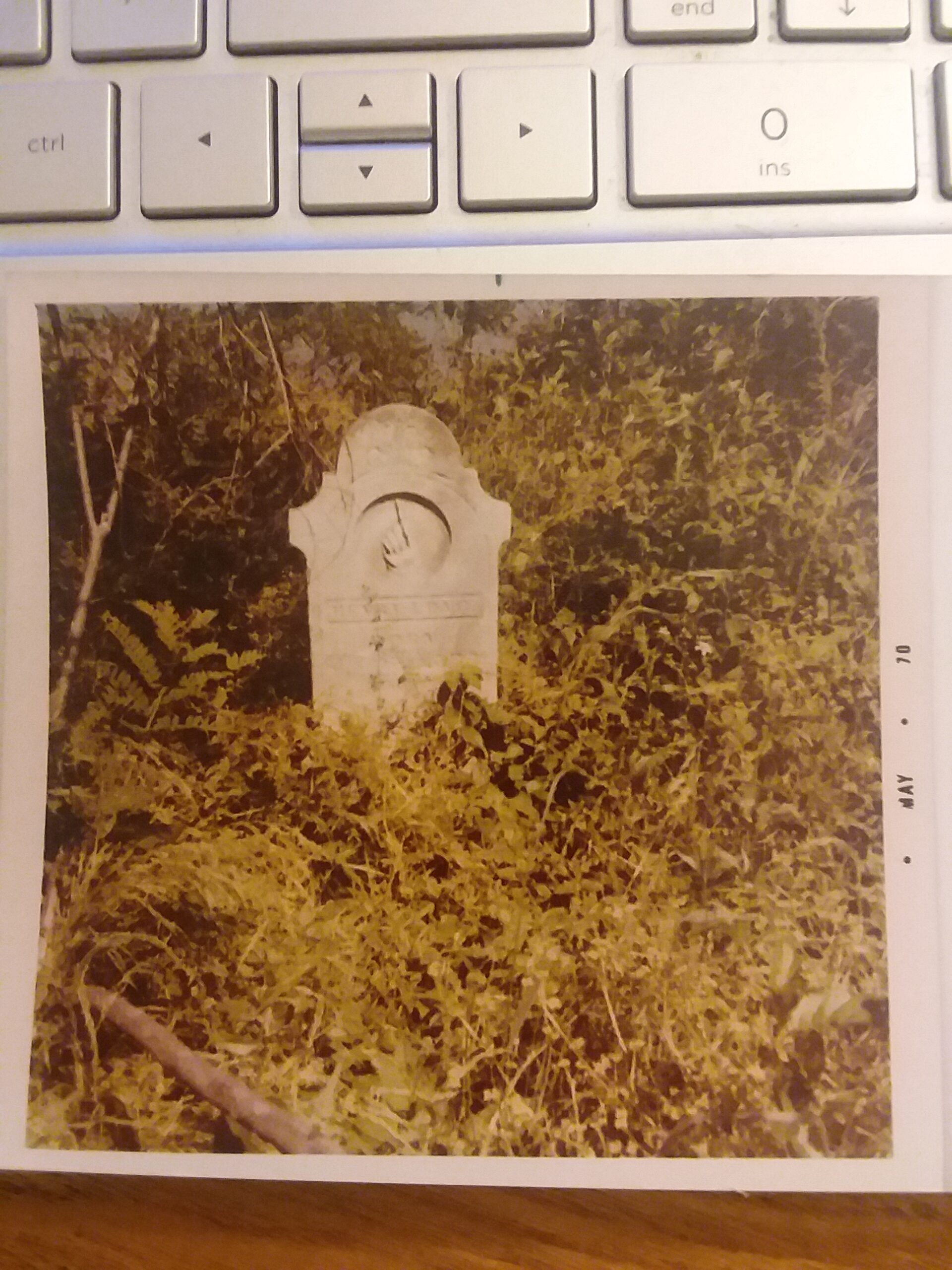
*1970 Photograph shows an overgrown gravesite (not underwater)
1999 TVA rights gravestones and builds perimeter of riprap
2014 Keith Harper discovers and becomes fascinated with The Submerged Cemetery at Mullins Cove.
During a recent public presentation of this research, a local resident approached me afterward and shared several personal photographs of the cemetery taken in May 1970. These images provide an important additional perspective on the final years of the cemetery before it disappeared beneath the waters of the Tennessee River.
In my original research, I concluded that the cemetery became submerged primarily and directly as a result of the rising waters following the construction of the original dam and the addition of flashboards in 1949. While that conclusion remains largely accurate, the 1970 photographs reveal another important factor that had not previously been documented in my research: significant erosion along the riverbank that particularly affected this cemetery.
The photographs show evidence that the gravestones where still standing upright on solid ground in 1970. This leads me to believe the soil surrounding the gravestones had already begun to wash away, lowering the ground level of the cemetery. This erosion likely allowed the stones to gradually sink below the waterline. In this way, the rising waters did not simply cover the cemetery all at once, but instead accelerated an erosion process that had already begun to undermine the site.
These newly discovered photographs help fill an important gap in the historical record and provide a more complete understanding of how the cemetery was ultimately lost beneath the Tennessee River.
In the end, this is the work of what I like to call “The Cemetery Detective.” Every cemetery is a quiet archive, filled with clues waiting to be uncovered; weathered gravestones, forgotten records, old family photographs, and memories carried by those who once walked these grounds. My investigation into this lost cemetery beneath the Tennessee River is only one chapter in a much larger story. Like any good mystery, the truth rarely reveals itself all at once. Sometimes the missing piece appears years later, tucked inside a shoebox of photographs or shared in a quiet conversation after a presentation.
That is the nature of cemetery research. It is not a finished product, but a living investigation. With every new discovery, the story grows richer and more complete. The past may be buried, but it is never truly gone. For those willing to keep searching, there are always more clues waiting to be found.
Keith Harper – The Cemetery Detective
About the Author – Keith Harper
Researcher, storyteller, and self-described “Cemetery Detective.”
I am a cemetery researcher and storyteller who enjoys uncovering the forgotten histories hidden within old burial grounds. Over the years I have documented cemeteries across the U.S.A. and beyond, studying gravestones, historical records, and the personal stories that connect families to these places. I sometimes refer to this work as being a “Cemetery Detective,” because each site presents its own mystery with clues scattered across weathered stones, fading documents, and memories passed down through generations.
What draws me to this work is the belief that cemeteries are more than resting places; they are quiet archives of local history. Every grave marker represents a life lived and a story worth remembering. Through research, writing, and public presentations, I try to piece together those stories so they are not lost to time. Like all historical research, this work is never truly finished. New evidence and new voices continue to emerge, reminding us that the past is always waiting to be rediscovered.